

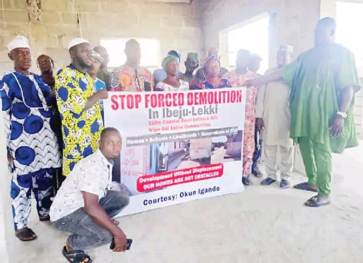
Communities in Ibeju-Lekki Local Government Area of Lagos State have raised alarm over an alleged plan by the Federal Government to enforce a 150-metre setback on both sides of the Lagos-Calabar Coastal Highway, warning that the move could further displace long-established settlements.
When our correspondent visited the axis on Thursday, community leaders said residents were living in fear following fresh markings reportedly carried out by officials, which they believe signal another round of demolitions.
Fears of Further Displacement
While acknowledging the coastal highway as a major infrastructure initiative, the leaders expressed concern over repeated realignments of the corridor, which they said had already led to the destruction of homes, shrines and ancestral landmarks.
They urged the Federal Ministry of Works and the Lagos State Government to provide clear clarification on the project’s alignment and setback provisions, and to engage affected communities before taking further action.
Chief Adebayo Agbabiaka, who spoke on behalf of the communities, said previous demolition exercises had displaced entire villages, including multi-storey buildings erected long before the coastal road project commenced.
He explained that years ago, residents transported building materials by boat through Epe before constructing homes in the area, underscoring the long-standing presence of the settlements.
According to him, compensation paid during earlier exercises was inadequate, noting that some affected families reportedly received between N9 million and N10 million — sums he argued would be insufficient to acquire land or resettle households in Ibeju-Lekki.
He added that although compensation was reportedly paid for crops, many homeowners were yet to be compensated for demolished structures.
Call for Waiver
Agbabiaka said new markings allegedly extended 150 metres to both the left and right sides of the highway corridor.
“If they take 150 metres on both sides, the communities will be severely affected. These are ancestral homes. If they are taken from us, where will we go?” he asked.
He stressed that residents were not resisting the project but were appealing for a waiver that would allow existing settlements to remain.
Similarly, the Chief Odofin of Opo-Ijebu Kingdom, Kunle Balogun, said the repeated adjustments to the project alignment had unsettled residents.
“After earlier demolitions and realignment, they are now talking about another 150 metres setback. What will be left of our communities?” he queried, urging the Federal Government to review the situation.
Another resident, Sharahu Ogunyemi, described the land as communal property and warned that enforcing the proposed setback could effectively erase entire settlements.
Federal Position
A source within the Federal Ministry of Works, who spoke anonymously because he was not authorised to comment officially, said the markings were carried out by the Office of the Surveyor General of the Federation.
According to the source, the exercise was intended to notify residents that properties within 150 metres on both sides of the corridor fall within federal right-of-way, adding that it did not automatically translate to immediate demolition.
When contacted, the Zonal Director of Survey Coordination, OSGOF Lagos, declined to comment.
Project Overview
The Lagos-Calabar Coastal Highway is a flagship federal infrastructure project designed to construct an estimated 700-kilometre road linking Lagos to Calabar. The route is expected to pass through several coastal states, including Ogun, Ondo, Edo, Delta, Bayelsa, Rivers and Akwa Ibom, before terminating in Cross River State.
Despite its projected economic benefits, property owners and investors along the corridor have continued to express concern over demolition notices, compensation processes and enforcement of setback regulations.
Last month, groups under the banner of Project Affected Persons also raised objections to directives reportedly requiring properties within a strict 150-metre setback from the high-water mark to be vacated.
The matter remains a source of tension as residents await official clarification on the extent and implications of the proposed setback enforcement.