

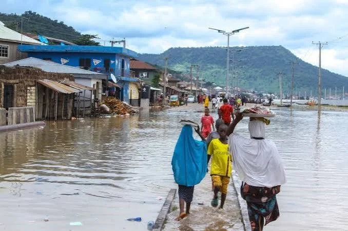
A severe downpour on June 28 submerged critical infrastructure, closed commercial hubs, and briefly paralyzed activities at the Murtala Muhammed International Airport international terminal, creating widespread anxiety over impending Lagos flood risks. The torrential weekend rainfall severely affected notable areas including Oshodi, Mushin, Surulere, Egbeda’s Akowonjo Road, Gbagada Expressway, and Idi-Oro. This incident struck just as regulatory bodies issued warnings regarding the peak flood season expected between July and September.
At the airport, rising waters forced the Federal Airports Authority of Nigeria to shut down operations at its temporary international facility when water reached the main powerhouse. Consequently, officials disconnected power grid access for safety, redirecting major international carriers such as Air France-KLM, Ethiopian Airlines, and Fly Gabon to Terminal Two. Meanwhile, urban areas like Gbagada, Ipaja, and Surulere witnessed knee-deep floods that trapped residents and halted daily commuting.
Videos circulating on social platforms depicted vehicles nearly submerged up to window levels, and commuters in Oshodi desperately seeking safety as portions of the public transit hub overflowed. The intense rainfall also breached domestic thresholds, leaving the lower levels of several residential buildings completely underwater. Although the water receded by Monday morning to allow business activities to slowly restart, traders and inhabitants lamented that the crisis highlights the state’s persistent exposure to environmental hazards despite public safety pledges.
The Nigerian Meteorological Agency (NiMet), the Nigeria Hydrological Services Agency (NIHSA), and the National Emergency Management Agency (NEMA) collectively designated the July-to-September window as the period of ultimate vulnerability. According to NiMet’s 2026 Seasonal Climate Prediction, a weak La Niña followed by a neutral ENSO phase has triggered predictions of an elongated rainy season with a delayed end. Projections show extreme annual precipitation reaching up to 2,010mm in Badagry and averaging 1,965mm across all 20 local government areas. Furthermore, NIHSA’s 2026 Annual Flood Outlook listed Lagos among 33 high-risk states, stating that a combination of rapid urbanization and overstretched drainage systems aggravates coastal and flash flood events.
To mitigate future occurrences, NEMA’s territorial arm flagged specific zones like Alimosho, Ikeja, and Epe as flash points, warning that Ikorodu and Isheri could face surges from the Oyan Dam. In response, Mahmood Adegbite, Permanent Secretary for the Office of Drainage Services and Water Resources, affirmed that flood mitigation is the administration’s primary directive. Adegbite revealed that a new flood insurance policy has been introduced via the Lagos State Emergency Management Agency to assist victims, while structural long-term projects—such as the 36-month System 1 drainage channel—are entering their initial phases of execution.
Reflecting on immediate causes, government officials noted that over a week of continuous rain had already fully saturated the soil and raised lagoon levels, thereby overwhelming existing networks. In reaction, Governor Babajide Sanwo-Olu greenlit emergency maintenance across major canals. Recent inspections also uncovered unauthorized real estate expansions on natural wetlands and waterways, prompting immediate demolition exercises. Additionally, the Ministry of Environment is contemplating future mandates requiring residential properties to allocate 40 percent of their plots to green spaces to enhance natural ground absorption.
While Commissioner for Environment and Water Resources Tokunbo Wahab urged the public to stay calm—characterizing the weekend crisis as transient flash flooding exacerbated by coastal topography—he admonished residents to stop dumping refuse in public drains. Having recently published an exhaustive list of endangered zones including Lekki, Apapa, and Lagos Island, authorities warn that the upcoming months represent the most challenging period of the year for communities situated near low-lying riverbanks.